Major Storm Headed for Santa Barbara Could Impact Holiday Travel Plans, NWS Warns

Major Winter Storm to Impact Santa Barbara County During Peak Holiday Travel

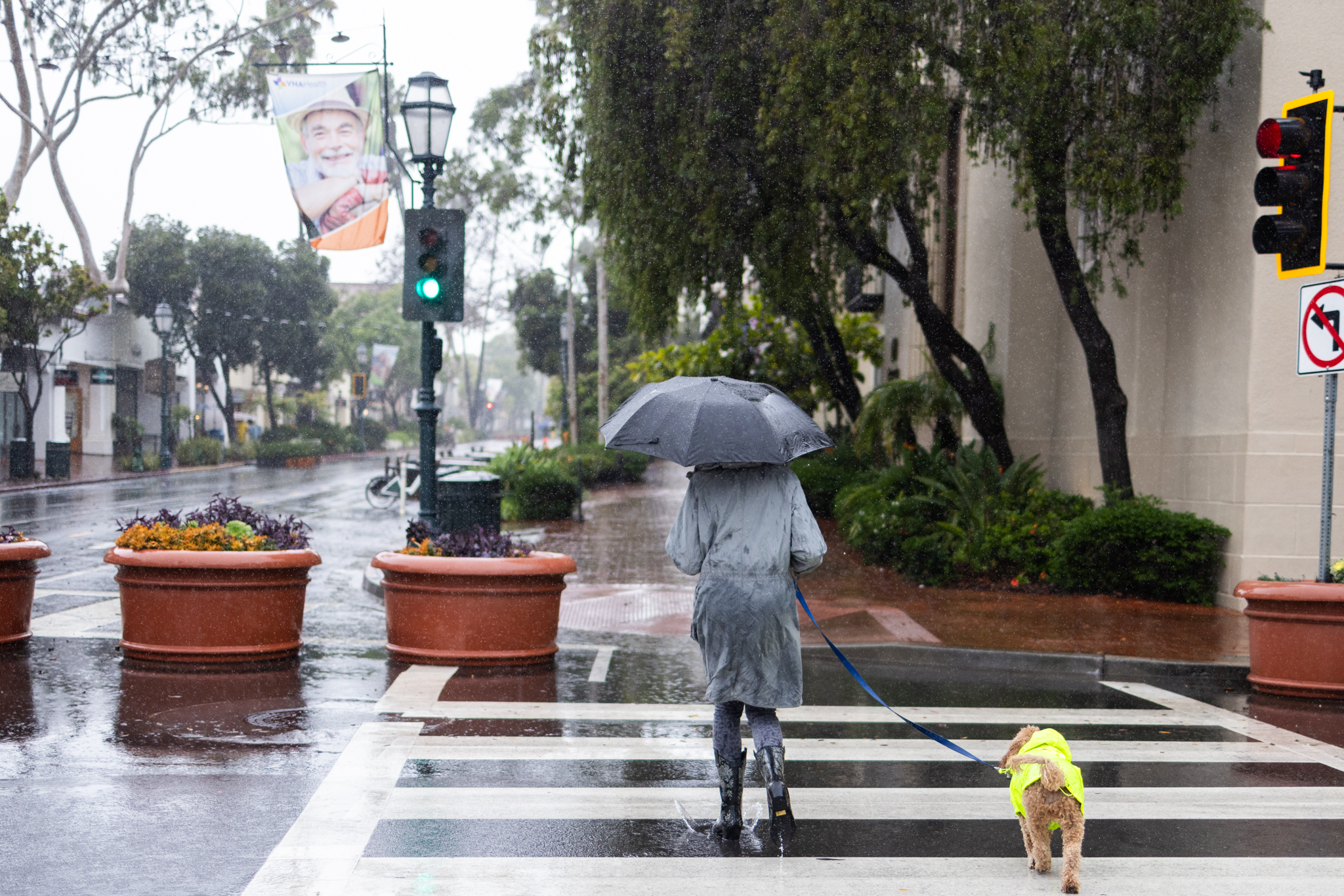
A major winter storm is expected to hit Santa Barbara County during the peak of holiday travel, with the worst impacts forecast between Tuesday night and Thursday morning on Christmas Day, according to alerts from the County of Santa Barbara and the National Weather Service (NWS).

“This is a significant storm system,” the NWS warned in its latest update on Friday. “Ample holiday travel impacts [are] expected Tue night through Thu. Plan for road & airport delays. Adjust holiday plans.”

Storm Details and Forecast

The storm could bring 2–4 inches of rain along the coast and 4–8 inches in the mountains, with peak hourly rain rates reaching up to 1 inch per hour in a higher-end scenario. There is also a 5–10 percent chance of thunderstorms on December 24 and 25. Snow levels could fall to 5,000–6,000 feet by the end of the storm.

The County of Santa Barbara issued a public alert Friday at 1:35 p.m., stating: “The National Weather Service is forecasting a major storm for Santa Barbara County that is expected to occur Tuesday, December 23 through Thursday, December 25.” Officials noted that lighter rain is possible starting Sunday and Monday.

Safety Precautions and Evacuations

While no evacuations are currently being issued, residents in flood-prone or unstable areas—particularly near recent wildfire burn scars—are urged to act early.

“If you are concerned that this storm may cause unsafe conditions to your home, leave the area before rain starts. Do not wait for an official evacuation notification to leave,” the county stated.

Flooding in low-lying areas, dangerous flash flooding, and strong winds are all anticipated countywide. The Santa Barbara coastline, beach bluffs, and harbor are expected to see heavy surf and erosion.

Officials warn that roads near burn areas, such as Highway 166, could be impacted by mudslides or rockfalls, possibly cutting off access to some communities.

Recommendations for Residents

For residents staying put, the county recommends a range of precautions, including:

  • Securing loose outdoor items.
  • Charging electronic devices.
  • Checking in on neighbors who may need support.

“If near a recent burn area, quickly move to the innermost room of your home or to higher ground such as a second floor,” the alert notes.

“Do not attempt to drive at night or while it is raining, as roads may be damaged or your car may be swept away by moving water or debris. NEVER drive, swim, or walk into floodwaters. Turn around, don’t drown!”

Timing and Additional Impacts

The most severe impacts for Santa Barbara County are expected Tuesday night into Christmas morning, according to a rainfall timing graph from the National Weather Service. The system is forecast to taper off by Friday.

In addition to heavy rain, widespread strong winds are expected Tuesday into Wednesday, with potential for downed trees and power outages. The NWS has advised residents to “stay off the ocean” and “park cars away from tall trees.”

Public Safety and Monitoring

Public safety agencies including Santa Barbara County Fire, Sheriff’s Office, and Office of Emergency Management are actively monitoring the storm.

“Officials will continue to assess if protective actions, such as an evacuation warning, evacuation order, or shelter in place are necessary,” the county alert stated.

Resources and Further Information

Santa Barbara County maintains a list of sandbag stations, road closure updates, and emergency alerts at ReadySBC.org.

https://www.independent.com/2025/12/19/major-storm-headed-for-santa-barbara-could-impact-holiday-travel-plans-nws-warns/

Oahu, Kauai, Niihau under flood watch starting late Saturday

A rain-packed weather front approaching Hawaii promises heavy rain and possible thunderstorms for the western islands from late Saturday through early next week, forecasters said.

The National Weather Service in Honolulu today issued a flood watch for Oahu, Kauai, and Niihau from late Saturday night through late Monday night.

“The potential for locally heavy showers and isolated thunderstorms will increase across the western end of the state as a front approaches from the northwest on Saturday, then stalls Sunday and Monday,” forecasters said.

They warned that flood-prone roads and low-lying areas may be closed due to elevated runoff and overflowing streams. “Urban areas may receive more significant flooding and property damage due to rapid runoff,” according to the flood watch.

The weather service noted that rainfall will be limited today and early Saturday, but a “stronger, moisture-laden front” will bring “enhanced showers and possible thunderstorms” to the western end of the state Sunday through Tuesday.
https://www.staradvertiser.com/2025/12/12/breaking-news/oahu-kauai-niihau-under-flood-watch-starting-late-saturday/

Ganado’s gameday moves to Friday, coach Ervin’s approach remains the same

The defending 2A D1 state champion and No. 2 ranked Ganado Indians (10-1, 6-0) enjoyed a blowout victory in last Thursday’s bi-district playoff contest. They faced off against the Three Rivers Bulldogs (4-7, 3-3) at Taft Greyhound Stadium in Taft and cruised to a decisive 55-0 victory. This week’s area playoff game will be played against the Thorndale Bulldogs (8-3, 4-1) Friday at 7 p. m. in Rockdale. The game was originally scheduled to be played Thursday night in Bastrop. The decision to move the game site and date was made Tuesday morning due to the high chance of thunderstorms in the area. Despite the scheduling change, Ganado head coach Josh Ervin said not much will change with his club’s preparation. “I think it’s going to be business as usual this week. We’ll have an extra day to get ready, but we’ll have the same approach,” coach Ervin said. Last week, Indians senior Austen Peña piled up 211 all-purpose yards and scored six touchdowns for Ganado. He rushed for 82 yards on six carries and hauled in five receptions for 129 yards. Peña is a wide receiver by trade who has filled in at running back when needed this season. It is the first year Peña has ever had any varsity snaps at the running back position. “It just speaks to his leadership qualities to learn a new position so quickly. He’s always ready to produce no matter where he lines up. He can even line up at quarterback, too,” coach Ervin said. Another standout performer for Ganado’s offense last week was sophomore quarterback Landyn Arriaga. He completed 9-of-12 passes for 190 yards and two scores and also rushed for a team-high 139 yards on 11 carries and two more touchdowns. Freshman defensive lineman Kole Bures also made his presence felt on the defensive side of the ball. Bures produced two sacks for a Ganado defense that allowed just 114 yards of total offense. “Kole is a very good athlete that can get off the ball very quickly and make plays,” coach Ervin said. One of Ganado’s standout performers along the offensive line is freshman starting left tackle Connor Todish. Coach Ervin believes Todish is very coachable and works hard to execute his blocks with proper technique. Todish’s contributions to the Indians offense has been a key factor in Ganado’s success. The freshman also plays as a reserve along the defensive line. “He’s taken this opportunity for extended playing time and just ran with it. He plays at a high level and improves every week. As for Thorndale, they come into the ballgame after last week’s 42-7 victory over Moody. It was Thorndale’s fifth straight win with their last loss coming on Oct. 10 at home against Mason. During the regular season, the Bulldogs placed second to Mason in District 14. Thorndale has rushed for 1, 571 yards and scored 23 touchdowns on the ground this year. Coach Ervin said it will take a disciplined defensive effort to contain the potent Thorndale rushing attack. “We are going to have to read our keys and our eyes in the backfield. They have a quick group of running backs that can make people miss,” coach Ervin said. “They execute on offense very well and their quarterback is a very accurate passer.”.
https://victoriaadvocate.com/2025/11/19/ganados-gameday-moves-to-friday-coach-ervins-approach-remains-the-same/

The Houston area faces a wet weekend after prolonged dry weather

After an extended dry spell, rain is expected to fall across the Houston area this weekend, bringing with it the chance for some localized flooding.

Isolated showers and thunderstorms are forecast for Friday, according to Bradley Brokamp, a meteorologist with the National Weather Service’s Houston-Galveston office. He said Friday morning that heavier rainfall is in the forecast for Saturday, with most of the region expected to receive 2-4 inches of rain, while some areas could get 4-6 inches.

The soil is expected to absorb more water than usual due to the recent dry weather, Brokamp noted. However, urban parts of Houston will “probably see some ponding in roadways on some spots.” “It’s Houston,” Brokamp said. “It’s a big slab of concrete that doesn’t really absorb water well.”

Saturday’s rain is anticipated to come in two waves, with the first wave arriving overnight between Friday and Saturday. A line of storms moving across Texas from west to east is also expected to bring strong winds to the Houston area and choppy waters along the Gulf Coast.

Wind could be the most significant impact to the region.

The risk for severe weather should dissipate by Sunday, Brokamp added.

Stormy weekend weather is expected across much of Texas, prompting Governor Greg Abbott to activate the state’s emergency response systems on Thursday afternoon. The governor’s office stated that many parts of the state face the “threat of severe thunderstorms including large hail, damaging winds, possible tornadoes, heavy rainfall, and flash flooding.”

“State and local emergency response partners are actively monitoring weather conditions and are on standby to provide all necessary resources to protect Texans and our communities,” Abbott said.

“Texans are encouraged to regularly monitor road conditions, make an emergency plan, and heed the guidance of state and local officials.”
https://www.houstonpublicmedia.org/articles/news/weather/2025/10/24/534181/houston-weather-rain-thunderstorms-flooding-governor-greg-abbott/?utm_source=rss-weather-article&utm_medium=link&utm_campaign=hpm-rss-link

‘Rhinos drown…roads turn rivers’: Bengal floods leave trail of destruction

**Rhinos Drown, Roads Turn Rivers: Bengal Floods Leave Trail of Destruction**
*By Snehil Singh | October 6, 2025, 5:13 PM*

Heavy, unabating rains in West Bengal have caused significant destruction, claiming the lives of at least 28 people and leaving dozens reported missing. The worst-hit area is Darjeeling, where the town of Mirik alone has witnessed 13 deaths, with many others still missing as rescue operations continue.

The severe downpours across North Bengal have triggered landslides, causing roads to collapse and stranding numerous tourists during the Durga Puja vacation period.

**Wildlife Impact**

A heartbreaking viral video from near Jaldapara National Park shows rhinos floating in floodwaters and even chasing people. Jaldapara is renowned for its population of the one-horned rhinoceros and other endangered species, many of which are severely affected by the floods.

The devastating weather has not spared neighboring Nepal either. According to *The Kathmandu Post*, water-induced disasters there have resulted in 47 deaths and nine people missing.

**Rescue Efforts**

In the midst of the chaos, elephants have emerged as unexpected heroes. Ravikant Jha, Assistant Wildlife Warden of Jaldapara, shared how elephants are aiding rescue efforts by transporting stranded tourists after a wooden bridge near a lodge collapsed. “Our elephants have brought 2-4 tourists across the river because the bridge broke due to rain,” he said.

Additionally, the National Disaster Response Force (NDRF) has been actively involved in flood and water rescue operations. They have successfully rescued over 160 people from the affected areas—105 by boat and another 55 either airlifted or pulled across using zip lines in Jalpaiguri. During these operations, one deceased individual was also recovered.

**Weather Forecast**

The India Meteorological Department has forecasted that scattered light to moderate rains will continue in the sub-Himalayan regions until October 12. Isolated thunderstorms, gusty winds reaching 30-40 km/h, and lightning are expected to persist until Tuesday morning.

The ongoing rains and floods continue to wreak havoc on both human lives and wildlife, highlighting the urgent need for sustained rescue efforts and disaster preparedness in the region.
https://www.newsbytesapp.com/news/india/floods-and-landslides-devastate-darjeeling-rhinos-float-in-floodwaters/story

‘Rhinos drown…roads turn rivers’: Bengal floods leave trail of destruction

Rhinos Drown, Roads Turn Rivers: Bengal Floods Leave Trail of Destruction

By Snehil Singh | Oct 06, 2025 | 05:13 PM

Heavy, unabating rains in West Bengal have caused widespread devastation, resulting in at least 28 deaths and leaving dozens missing. The worst-hit region is Darjeeling, where Mirik alone has reported 13 fatalities, with many more still unaccounted for as rescue operations continue.

The intense downpours in North Bengal have triggered landslides, causing roads to collapse and stranding numerous tourists during the Durga Puja vacations. Infrastructure damage and disrupted transportation have further complicated relief efforts.

Wildlife Impact

A viral video from near Jaldapara National Park shows rhinos floating helplessly in floodwaters and even chasing people. The park is known for its population of the famous one-horned rhinoceros and other endangered species, raising concerns about the safety of wildlife amid the floods.

Severe weather has also severely affected neighboring Nepal, where water-induced disasters have claimed 47 lives, with nine more reported missing, according to The Kathmandu Post.

Rescue Efforts

Elephants have emerged as unlikely heroes in the rescue operations. Ravikant Jha, Assistant Wildlife Warden of Jaldapara, shared that elephants have been used to transport stranded tourists after a wooden bridge near a lodge collapsed due to heavy rain. “Our elephants have brought 2-4 tourists across the river because the bridge near the lodge broke,” he said.

The National Disaster Response Force (NDRF) has been actively involved in flood and water rescue operations. So far, the NDRF has rescued over 160 people from affected areas. Of these, 105 were rescued by boats, while another 55 were either airlifted or pulled across rivers using zip lines in Jalpaiguri. Rescue teams also recovered one deceased individual during their operations.

Weather Forecast

The India Meteorological Department has forecast continued scattered light to moderate rain in the sub-Himalayan regions until October 12. Thunderstorms, gusty winds reaching 30-40 km/h, and isolated lightning strikes are expected until Tuesday morning, signaling the need for ongoing caution and preparedness.

Stay safe and follow official advisories as relief and rescue efforts continue across the region.

https://www.newsbytesapp.com/news/india/floods-and-landslides-devastate-darjeeling-rhinos-float-in-floodwaters/story

Exit mobile version
Sitemap Index