‘Life-Threatening Damage’: Hurricane Melissa Makes Landfall in Cuba After Battering Jamaica

**Hurricane Melissa Strikes Eastern Cuba After Devastating Jamaica as Category 5 Storm**

Hurricane Melissa made landfall in eastern Cuba early Wednesday as a Category 3 storm, following its brutal impact on Jamaica as a Category 5 hurricane. The storm inflicted widespread damage across Jamaica, particularly near the town of New Hope, where homes and businesses were destroyed.

Evan Thompson, Principal Director at Meteorological Service Jamaica, issued a grave warning ahead of the storm’s arrival: “It will cause catastrophic damage, life-threatening damage. There is very little that can stop a Category 5 hurricane.”

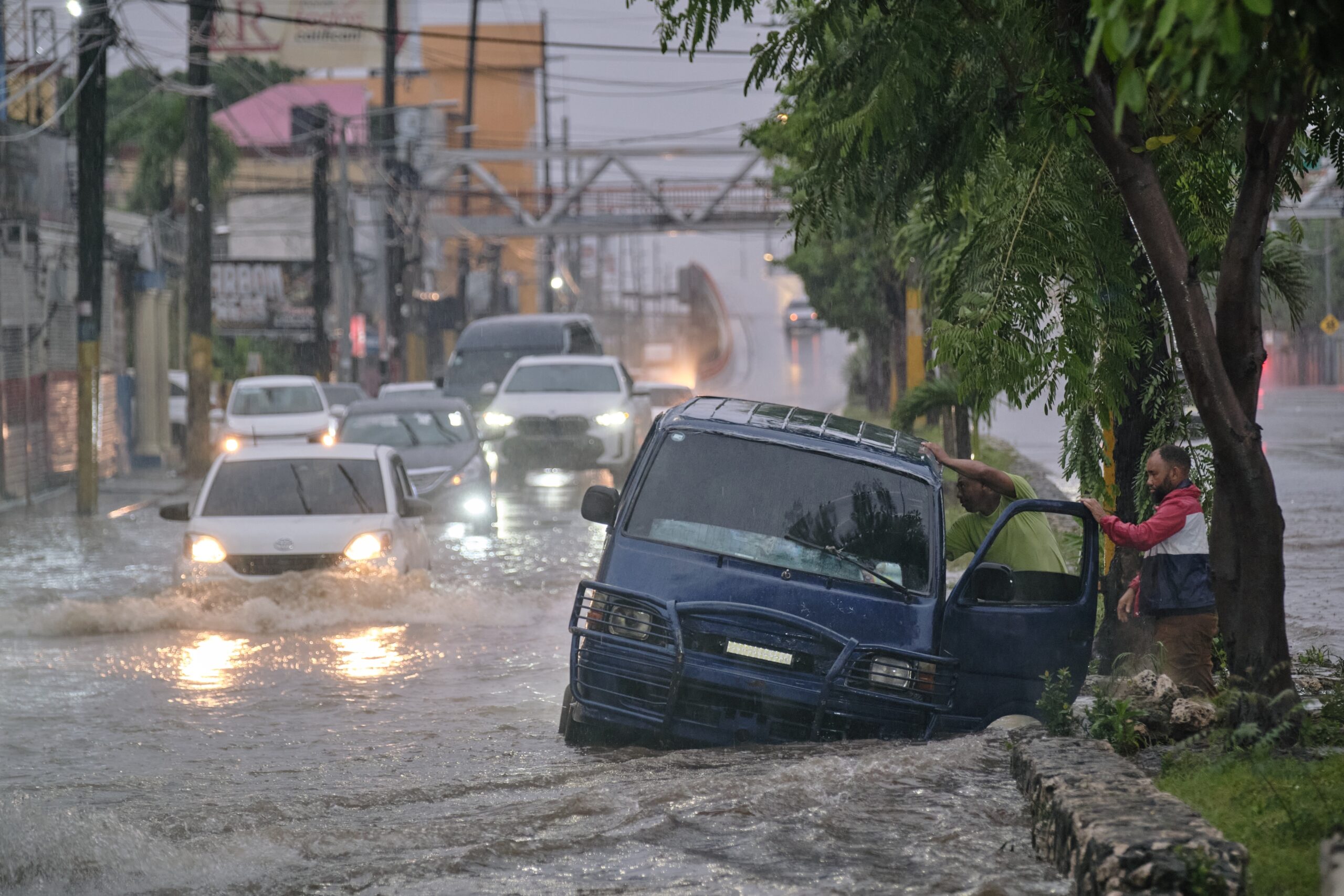
Powerful winds and fallen trees have left a trail of destruction and life-threatening flooding throughout the island. Roads remain impassable as storm surges reaching up to 13 feet inundate coastal areas. The parish of St. Elizabeth is reportedly underwater, and over half a million residents are currently without power.

Four main hospitals sustained damage during the storm, with one losing power completely, forcing the evacuation of 75 patients. In response to the crisis, the Prime Minister of Jamaica declared the entire island a disaster area.

For many residents, Hurricane Melissa has upended lives and plans. Shantelle Nova shared her experience as her dream wedding venue flooded and was severely damaged. “Windows are broken, a lot of water is coming in, so we’re just basically pushing towels and stuff at the doors,” Nova said. “The level of noise is ridiculous. Trees have really bent over and flown away, and some of our roof is completely off.”

**Severe Flooding Hits Cuba**

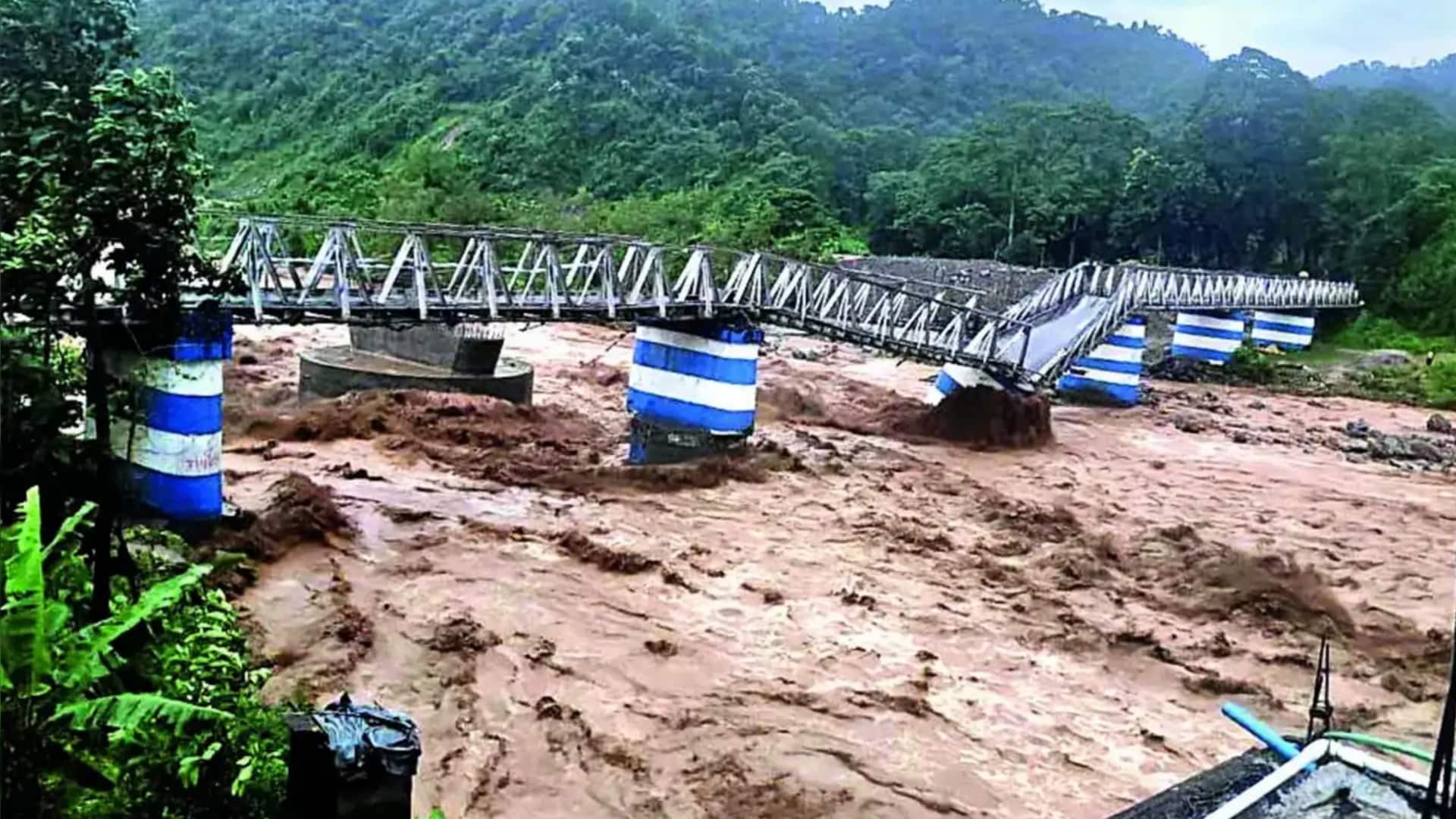
In Cuba, severe flooding overwhelmed streets in Santiago de Cuba as the storm brought heavy rains and strong winds before making landfall. Some areas were forecast to receive up to 20 inches of rain along with significant coastal storm surge.

Approximately 500,000 people were evacuated from vulnerable areas in anticipation of high winds and flooding as Melissa swept across the Caribbean.

**Operation Blessing Prepares to Assist Storm Victims**

CBN’s Operation Blessing (OB) is actively preparing to assist those affected by Hurricane Melissa. Teams have been packing essential supplies and readying for deployment to the impacted regions.

On CBN’s Faith Nation, Diego Traverso, Senior Director for Operation Blessing’s Global Disaster Response Team, highlighted the challenges ahead:
“We don’t know how catastrophic this is going to be, if the water is going to recede, if the airports are going to be open and when they’re going to be open. So, at this point, we are just getting ready as close as we can to the island and praying for favor so we can either ride on a private or commercial airplane.”

The OB team is assembling much-needed disaster relief supplies, including water, food, solar lamps, hygiene kits, chlorinators, and water purification units to ensure access to clean drinking water.

Traverso emphasized the critical nature of clean water: “Water is going to be critical; the different ways for them to get water is going to get polluted. Pray for the people of Jamaica. Pray for the team of Operation Blessing.”

In addition to supplies, Operation Blessing is preparing cargo shipments with pallets of food and hygiene products for families in need.

**Looking Ahead: Hurricane Melissa Moves Toward the Bahamas**

Hurricane Melissa is forecast to move into the Bahamas later Wednesday. Jamaican officials are hopeful that airports will reopen by Thursday, facilitating recovery and relief efforts.

Meanwhile, U.S. President Donald Trump has stated that the United States is prepared to send aid to support those affected by the devastating storm.

*Stay tuned for updates on Hurricane Melissa and relief efforts as the situation develops.*
https://www1.cbn.com/cbnnews/world/2025/october/life-threatening-damage-hurricane-melissa-makes-landfall-in-cuba-after-battering-jamaica

U.S. winter weather outlook and how La Niña will factor in

EarthSky isn’t powered by billionaires. We’re powered by you. Support EarthSky’s 2025 Donation Campaign and help keep science accessible.

**La Niña’s Impact on the U.S. Winter Weather Outlook**

The Climate Prediction Center has issued a La Niña Advisory, confirming that La Niña has formed in the tropical Pacific Ocean and is likely to continue through February 2026.

La Niña is one phase of ENSO, or El Niño Southern Oscillation — a global climate system that impacts atmospheric circulation worldwide, influencing weather patterns across the globe. La Niña is often considered the cool phase of ENSO because it occurs when waters of the tropical Pacific Ocean are cooler than average.

This cooling causes dry, sinking air over the tropical Pacific while air rises near Southeast Asia, leading to increased clouds, rainfall, and storm activity in that region.

### What Does La Niña Mean for U.S. Winter Weather?

The effects of La Niña on winter weather vary depending on where you are in the United States.

During a La Niña winter, the jet stream across North America tends to be more variable. It usually drifts farther north over the northern Pacific and sometimes farther south across the southern United States, though the exact position can fluctuate.

This pattern generally results in:

– **Cooler and wetter conditions** from southern Alaska through western Canada and into the northern Plains of the United States.
– **Drier and warmer weather** stretching from California through the Gulf Coast and extending toward the Carolinas.
– **Wetter than average conditions** around areas close to the jet stream’s path, typically near the Ohio and Mississippi River Valleys.

### Winter Weather Outlook from the Climate Prediction Center

The Climate Prediction Center’s Winter Weather Outlook for the U.S. reflects these La Niña influences and covers December, January, and February — the meteorological winter.

Meteorologists prefer meteorological winter (December 1 through February 28/29) over astronomical winter (which starts around December 21) for forecasting seasonal temperature and precipitation averages, since the dates remain consistent each year.

According to the CPC outlook:

– Much of the U.S. from California through Texas, the Gulf Coast, Southeast, and up toward the Mid-Atlantic is likely to experience **warmer-than-average temperatures** this winter.
– The **northern Plains** of the U.S. have the highest chance of **cooler-than-average temperatures**.
– For precipitation, much of the northern and central U.S. is favored to receive **wetter-than-normal conditions**, while drier weather is expected over the southern half of the country.

### Important Note: A Winter Outlook Is Not an Exact Forecast

Seasonal outlooks provide broad trends, not precise daily forecasts. While La Niña will influence this winter’s weather, it doesn’t guarantee consistent conditions.

– Areas predicted to be drier than normal may still experience rainy or snowy days.
– Regions expected to be cooler on average might still see warm winter days.

This outlook represents the most likely scenario over the entire three-month winter season. For the most up-to-date and localized forecasts, be sure to consult your local National Weather Service office throughout the season.

### Bottom Line

La Niña has developed in the tropical Pacific and is expected to remain through February 2026. This will shape the winter weather we experience, but the exact impacts depend on your location.

For more information, read more about [El Niño](#).

Thank you for supporting EarthSky — your contributions help keep science accessible to all.
https://earthsky.org/earth/us-winter-weather-outlook-la-nina/

Delhi-NCR air quality worsens; 5 stations record 300+ AQI

**Delhi-NCR Air Quality Worsens; Five Stations Record AQI Above 300**

*By Snehil Singh | Oct 15, 2025, 06:12 pm*

The air quality in the Delhi-National Capital Region (NCR) has further deteriorated, with five monitoring stations registering an Air Quality Index (AQI) exceeding 300. According to data from the Central Pollution Control Board (CPCB), Anand Vihar recorded the highest AQI at a staggering 345.

Other areas also reported alarming AQI figures: DU North Campus and CRRI Mathura Road each recorded 307, while Dwarka Sector 8 and Wazirpur reported 314 and 325, respectively.

**Pollution Response: GRAP Stage-1 Activated**

In response to the worsening air quality, the Commission for Air Quality Management (CAQM) has activated Stage-1 of the Graded Response Action Plan (GRAP) across Delhi-NCR. This comes as AQI levels have fallen between 200 and 300, categorized as “poor.”

Stage-1 implementation mandates strict preventive measures, including the deployment of anti-smog guns and dust suppression activities at construction sites to control pollution sources.

**Pollution Sources: Transport Emissions Lead**

Data from the Decision Support System (DSS) identifies transport emissions as the largest contributor to Delhi’s pollution, accounting for 19.8% of total emissions. On Tuesday, the city recorded an AQI of 201, falling under the “poor” air quality category.

For reference, the CPCB classifies AQI as follows:
– 0-50: Good
– 51-100: Satisfactory
– 101-200: Moderate
– 201-300: Poor
– 301-400: Very Poor
– Above 400: Severe

**Weather Impact**

The India Meteorological Department (IMD) noted that Delhi’s minimum temperature on Wednesday was 18.3°C — slightly below the normal of 19.6°C. This marks the fifth consecutive day with minimum temperatures under 20°C for the 2025-26 winter season. The maximum temperature hovered around 33°C.

Meanwhile, relative humidity was high at 89% as recorded at 8:30 am, factors that could further affect air quality levels.

Residents are advised to take necessary precautions as the air pollution situation remains critical.
https://www.newsbytesapp.com/news/delhi/delhi-ncr-air-quality-worsens-5-stations-record-300-aqi/story

Why Delhi’s air quality may become ‘poor’ from Wednesday

**Why Delhi’s Air Quality May Become ‘Poor’ from Wednesday**
*By Snehil Singh | October 13, 2025 | 8:30 PM*

The India Meteorological Department (IMD) has forecast a decline in Delhi’s air quality as the winter season approaches. The city’s air is expected to remain in the “moderate” category on October 13 and 14 but will likely slip into the “poor” category for nearly a week starting October 15.

According to the IMD bulletin, “The air quality is very likely to be in the Moderate category from October 13-14. From October 15 onwards, it is expected to be in the Poor category for nearly a week.”

### Pollution Update: Slight Increase in Stubble Burning

Delhi’s air quality showed a slight improvement on Sunday, with an average Air Quality Index (AQI) of 167, down from 199 on Saturday. This improvement was attributed to steady winds blowing at 10-15 km/h.

However, stubble burning in neighboring states has increased slightly, contributing to pollution levels in the city. The share of pollution from stubble burning rose from 0.4% on Saturday to 0.8% on Sunday.

The Ministry of Earth Sciences’ Early Warning System also predicts moderate air quality for October 13-14 and poor conditions from October 15 onward.

### Factors Behind the Pollution Spike

Delhi’s air quality typically worsens in October due to several reasons:

– Retreating monsoon rains and cooler temperatures
– Increased stubble burning in Punjab, Haryana, and nearby states
– Festive fireworks adding to pollution levels

Additionally, slower winds and cooler weather during this season lead to a “temperature inversion,” where a layer of warm air traps pollutants near the ground, worsening air quality. Smoke carried by north-westerly winds from Punjab and Haryana further aggravates the situation.

On Sunday, vehicles were the largest contributors to PM2.5 pollution, accounting for 19.8%, followed by emissions from Sonipat (9.2%) and Jhajjar (5.1%).

### Seasonal Outlook: Clear Skies and Cool Winds

The IMD has forecast clear skies and cool northwesterly winds over the coming days, with maximum temperatures expected to rise to 34°C by Wednesday.

Environment Minister Manjinder Singh Sirsa highlighted that Delhi has recorded 199 days with AQI below 200 this year, nearly double the number reported in 2016. He said this marks a “real improvement on the ground.”

As winter advances, residents are advised to stay updated on air quality forecasts and take necessary precautions, especially from mid-October when pollution levels are expected to worsen.

*Stay tuned for more updates on Delhi’s air quality and pollution management.*
https://www.newsbytesapp.com/news/india/delhi-air-quality-to-turn-poor-from-wednesday/story

Fresh snowfall recorded in higher reaches of Kashmir

After heavy rains lashed parts of Jammu and Kashmir, the weather situation has now shifted dramatically. According to news agency PTI, fresh snowfall has blanketed several famous tourist resorts and higher reaches in Kashmir, creating a picturesque winter landscape.

Officials reported that the plains experienced rainfall followed by snowfall, leading to a sharp drop in day temperatures across the valley. Regions such as Gulmarg, Pahalgam, Sonamarg, Aru Valley, Chandanwari, and Kokernag were among the areas that received fresh snowfall.

Other places witnessing snowfall included Peer Ki Gali on the Mughal Road in Shopian district and Zojila Pass along the Srinagar-Leh national highway. Fresh snow was also reported in higher reaches like Sinthan Top in Anantnag district, Affarwat in Gulmarg, and Razdan Pass in Gurez valley.

Meanwhile, light to moderate rainfall was recorded in the plains of Kashmir, including Srinagar city. Despite the pleasant weather, the day temperature in the valley dropped significantly by 13 degrees Celsius. Srinagar recorded a maximum temperature of just 12.5 degrees Celsius on Monday, compared to the normal 25.5 degrees Celsius.

The Meteorological Department has forecasted light to moderate rain, accompanied by light snowfall in the higher reaches, continuing till Tuesday afternoon. However, weather officials expect conditions across various districts to improve afterwards.

Earlier in September, Jammu faced heavy rainfall that severely disrupted daily life. Flood-like situations in districts such as Doda and Raesi caused widespread infrastructural damage. The intense weather and landslides also damaged the Jammu-Pathankot highway bridge.

During the crisis, the State Disaster Response Force (SDRF) rescued 45 students from flooded IIIM hostels. The Indian Army evacuated several people trapped in the valley, while officials organized flood-relief camps to ensure swift rehabilitation.

(With inputs from PTI)
https://www.mid-day.com/news/india-news/article/fresh-snowfall-hits-kashmir-after-heavy-rains-temperatures-eases-across-valley-23597603

‘Rhinos drown…roads turn rivers’: Bengal floods leave trail of destruction

**Rhinos Drown, Roads Turn Rivers: Bengal Floods Leave Trail of Destruction**
*By Snehil Singh | October 6, 2025, 5:13 PM*

Heavy, unabating rains in West Bengal have caused significant destruction, claiming the lives of at least 28 people and leaving dozens reported missing. The worst-hit area is Darjeeling, where the town of Mirik alone has witnessed 13 deaths, with many others still missing as rescue operations continue.

The severe downpours across North Bengal have triggered landslides, causing roads to collapse and stranding numerous tourists during the Durga Puja vacation period.

**Wildlife Impact**

A heartbreaking viral video from near Jaldapara National Park shows rhinos floating in floodwaters and even chasing people. Jaldapara is renowned for its population of the one-horned rhinoceros and other endangered species, many of which are severely affected by the floods.

The devastating weather has not spared neighboring Nepal either. According to *The Kathmandu Post*, water-induced disasters there have resulted in 47 deaths and nine people missing.

**Rescue Efforts**

In the midst of the chaos, elephants have emerged as unexpected heroes. Ravikant Jha, Assistant Wildlife Warden of Jaldapara, shared how elephants are aiding rescue efforts by transporting stranded tourists after a wooden bridge near a lodge collapsed. “Our elephants have brought 2-4 tourists across the river because the bridge broke due to rain,” he said.

Additionally, the National Disaster Response Force (NDRF) has been actively involved in flood and water rescue operations. They have successfully rescued over 160 people from the affected areas—105 by boat and another 55 either airlifted or pulled across using zip lines in Jalpaiguri. During these operations, one deceased individual was also recovered.

**Weather Forecast**

The India Meteorological Department has forecasted that scattered light to moderate rains will continue in the sub-Himalayan regions until October 12. Isolated thunderstorms, gusty winds reaching 30-40 km/h, and lightning are expected to persist until Tuesday morning.

The ongoing rains and floods continue to wreak havoc on both human lives and wildlife, highlighting the urgent need for sustained rescue efforts and disaster preparedness in the region.
https://www.newsbytesapp.com/news/india/floods-and-landslides-devastate-darjeeling-rhinos-float-in-floodwaters/story

‘Rhinos drown…roads turn rivers’: Bengal floods leave trail of destruction

Rhinos Drown, Roads Turn Rivers: Bengal Floods Leave Trail of Destruction

By Snehil Singh | Oct 06, 2025 | 05:13 PM

Heavy, unabating rains in West Bengal have caused widespread devastation, resulting in at least 28 deaths and leaving dozens missing. The worst-hit region is Darjeeling, where Mirik alone has reported 13 fatalities, with many more still unaccounted for as rescue operations continue.

The intense downpours in North Bengal have triggered landslides, causing roads to collapse and stranding numerous tourists during the Durga Puja vacations. Infrastructure damage and disrupted transportation have further complicated relief efforts.

Wildlife Impact

A viral video from near Jaldapara National Park shows rhinos floating helplessly in floodwaters and even chasing people. The park is known for its population of the famous one-horned rhinoceros and other endangered species, raising concerns about the safety of wildlife amid the floods.

Severe weather has also severely affected neighboring Nepal, where water-induced disasters have claimed 47 lives, with nine more reported missing, according to The Kathmandu Post.

Rescue Efforts

Elephants have emerged as unlikely heroes in the rescue operations. Ravikant Jha, Assistant Wildlife Warden of Jaldapara, shared that elephants have been used to transport stranded tourists after a wooden bridge near a lodge collapsed due to heavy rain. “Our elephants have brought 2-4 tourists across the river because the bridge near the lodge broke,” he said.

The National Disaster Response Force (NDRF) has been actively involved in flood and water rescue operations. So far, the NDRF has rescued over 160 people from affected areas. Of these, 105 were rescued by boats, while another 55 were either airlifted or pulled across rivers using zip lines in Jalpaiguri. Rescue teams also recovered one deceased individual during their operations.

Weather Forecast

The India Meteorological Department has forecast continued scattered light to moderate rain in the sub-Himalayan regions until October 12. Thunderstorms, gusty winds reaching 30-40 km/h, and isolated lightning strikes are expected until Tuesday morning, signaling the need for ongoing caution and preparedness.

Stay safe and follow official advisories as relief and rescue efforts continue across the region.

https://www.newsbytesapp.com/news/india/floods-and-landslides-devastate-darjeeling-rhinos-float-in-floodwaters/story

Exit mobile version