Melissa strengthens into a Category 4 hurricane, threatening catastrophic flooding in Jamaica, Haiti

Hurricane Melissa Strengthens to Major Category 4 Storm, Threatening Northern Caribbean

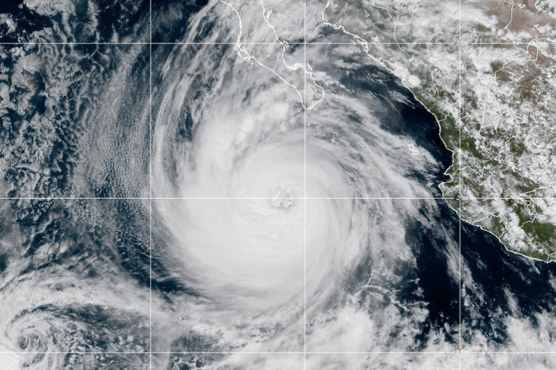
KINGSTON, Jamaica (AP) — Hurricane Melissa has intensified into a major Category 4 hurricane, with the potential to strengthen further into a Category 5 storm Sunday night. The hurricane is unleashing torrential rains and poses a severe flooding threat across the northern Caribbean, including Haiti and Jamaica, the U.S. National Hurricane Center (NHC) reported.

The NHC added that Melissa is expected to reach the southern coast of Jamaica as a major hurricane late Monday or Tuesday morning, urging residents to seek shelter immediately.

“I urge Jamaicans to take this weather threat seriously,” said Jamaican Prime Minister Andrew Holness. “Take all measures to protect yourself.”

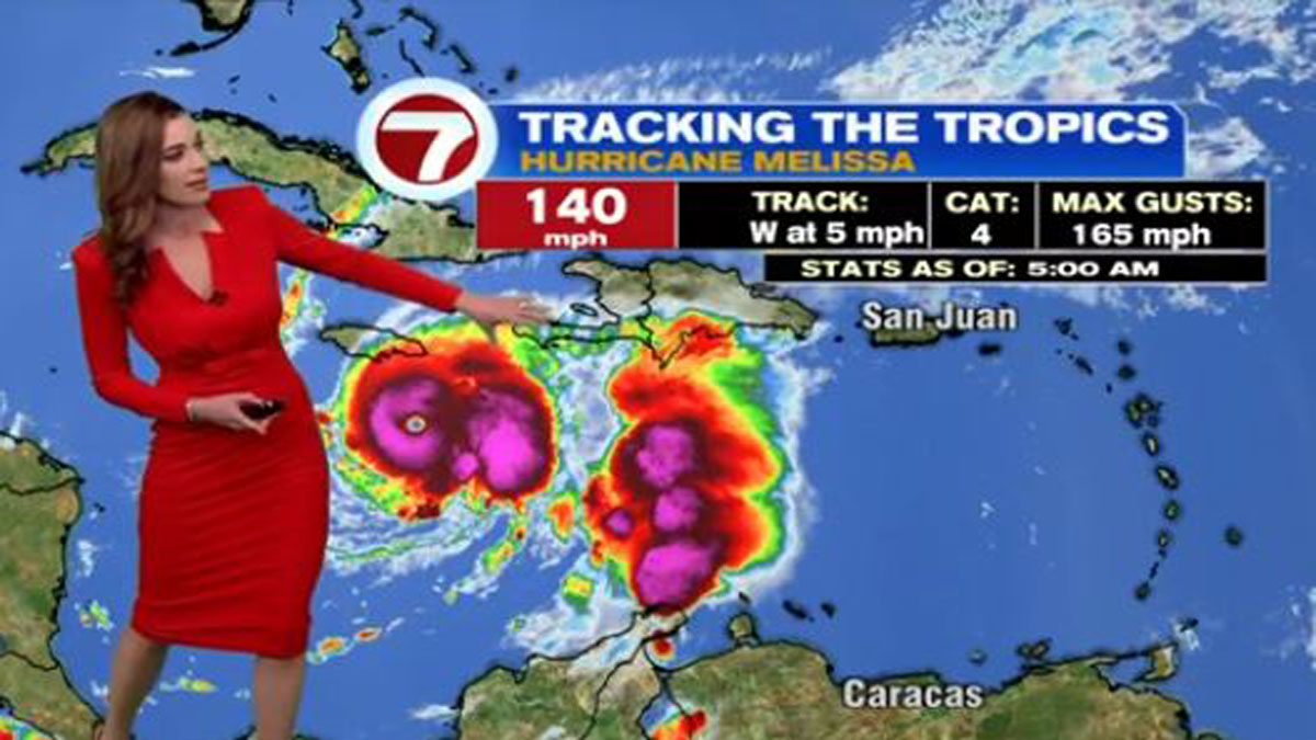
As of Sunday morning, Melissa was centered approximately 120 miles (195 kilometers) south-southeast of Kingston, Jamaica, and about 280 miles (450 kilometers) south-southwest of Guantanamo, Cuba. The storm had maximum sustained winds of 140 mph (225 kph) and was moving west at 5 mph (8 kph).

Heavy Rainfall and Widespread Impact Expected

Melissa is forecast to drop torrential rains of up to 30 inches (760 millimeters) on Jamaica and southern Hispaniola, including Haiti and the Dominican Republic. Some areas could see as much as 40 inches (1,010 millimeters) of rainfall.

The hurricane center warned of extensive damage to infrastructure, power and communication outages, and the potential isolation of communities in Jamaica.

After affecting Jamaica, Melissa should be near or over Cuba by late Tuesday, potentially bringing up to 12 inches (300 millimeters) of rain before moving toward the Bahamas late Wednesday.

In response, the Cuban government issued a hurricane watch Saturday afternoon for the provinces of Granma, Santiago de Cuba, Guantanamo, and Holguin.

Storm’s Slow Progress and Fatalities

The erratic and slow-moving hurricane has already claimed at least three lives in Haiti and a fourth in the Dominican Republic, where another person is still missing.

“Unfortunately for places along the projected path of this storm, it is increasingly dire,” said Jamie Rhome, deputy director of the NHC, earlier on Saturday. He added that Melissa is expected to continue moving slowly for up to four days.

Jamaica Prepares for Impact

Authorities in Jamaica announced Saturday that the Norman Manley International Airport in Kingston would close at 8 p.m. local time. It remains unclear whether the Sangster airport in Montego Bay on the island’s western side will also close.

More than 650 shelters have been activated across Jamaica. Officials confirmed that warehouses are well-stocked with thousands of food packages prepositioned for rapid distribution if needed.

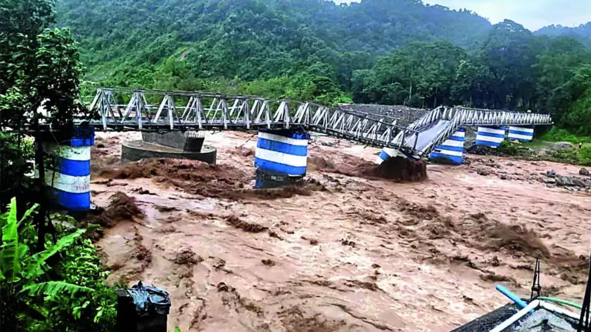
Rising River Levels and Damage in Haiti and Dominican Republic

Haitian authorities reported three deaths linked to the hurricane and five injuries caused by a collapsed wall. Rising river levels, flooding, and a destroyed bridge due to breached riverbanks have been reported in Sainte-Suzanne in northeast Haiti.

Ronald Délice, a Haitian civil protection director, expressed concern about the storm’s trajectory. Local authorities are organizing lines for food kit distributions, although many residents remain reluctant to leave their homes.

In the Dominican Republic, Melissa has damaged nearly 200 homes and disrupted water supply systems affecting more than half a million people. The storm also downed trees and traffic lights, caused small landslides, and isolated over two dozen communities with floodwaters.

Threat to The Bahamas and Turks and Caicos

The Bahamas Department of Meteorology warned that tropical storm or hurricane conditions could affect islands in the Southeast and Central Bahamas and the Turks and Caicos Islands by early next week.

Season Overview

Melissa is the 13th named storm of the 2024 Atlantic hurricane season, which officially runs from June 1 to November 30. The U.S. National Oceanic and Atmospheric Administration (NOAA) had forecast an above-normal season, predicting 13 to 18 named storms.

___

Associated Press writer Evens Sanon in Port-au-Prince, Haiti, contributed to this report.

https://whdh.com/news/melissa-strengthens-into-a-category-4-hurricane-threatening-catastrophic-flooding-in-jamaica-haiti/

The Houston area faces a wet weekend after prolonged dry weather

After an extended dry spell, rain is expected to fall across the Houston area this weekend, bringing with it the chance for some localized flooding.

Isolated showers and thunderstorms are forecast for Friday, according to Bradley Brokamp, a meteorologist with the National Weather Service’s Houston-Galveston office. He said Friday morning that heavier rainfall is in the forecast for Saturday, with most of the region expected to receive 2-4 inches of rain, while some areas could get 4-6 inches.

The soil is expected to absorb more water than usual due to the recent dry weather, Brokamp noted. However, urban parts of Houston will “probably see some ponding in roadways on some spots.” “It’s Houston,” Brokamp said. “It’s a big slab of concrete that doesn’t really absorb water well.”

Saturday’s rain is anticipated to come in two waves, with the first wave arriving overnight between Friday and Saturday. A line of storms moving across Texas from west to east is also expected to bring strong winds to the Houston area and choppy waters along the Gulf Coast.

Wind could be the most significant impact to the region.

The risk for severe weather should dissipate by Sunday, Brokamp added.

Stormy weekend weather is expected across much of Texas, prompting Governor Greg Abbott to activate the state’s emergency response systems on Thursday afternoon. The governor’s office stated that many parts of the state face the “threat of severe thunderstorms including large hail, damaging winds, possible tornadoes, heavy rainfall, and flash flooding.”

“State and local emergency response partners are actively monitoring weather conditions and are on standby to provide all necessary resources to protect Texans and our communities,” Abbott said.

“Texans are encouraged to regularly monitor road conditions, make an emergency plan, and heed the guidance of state and local officials.”
https://www.houstonpublicmedia.org/articles/news/weather/2025/10/24/534181/houston-weather-rain-thunderstorms-flooding-governor-greg-abbott/?utm_source=rss-weather-article&utm_medium=link&utm_campaign=hpm-rss-link

Delhi-NCR air quality worsens; 5 stations record 300+ AQI

**Delhi-NCR Air Quality Worsens; Five Stations Record AQI Above 300**

*By Snehil Singh | Oct 15, 2025, 06:12 pm*

The air quality in the Delhi-National Capital Region (NCR) has further deteriorated, with five monitoring stations registering an Air Quality Index (AQI) exceeding 300. According to data from the Central Pollution Control Board (CPCB), Anand Vihar recorded the highest AQI at a staggering 345.

Other areas also reported alarming AQI figures: DU North Campus and CRRI Mathura Road each recorded 307, while Dwarka Sector 8 and Wazirpur reported 314 and 325, respectively.

**Pollution Response: GRAP Stage-1 Activated**

In response to the worsening air quality, the Commission for Air Quality Management (CAQM) has activated Stage-1 of the Graded Response Action Plan (GRAP) across Delhi-NCR. This comes as AQI levels have fallen between 200 and 300, categorized as “poor.”

Stage-1 implementation mandates strict preventive measures, including the deployment of anti-smog guns and dust suppression activities at construction sites to control pollution sources.

**Pollution Sources: Transport Emissions Lead**

Data from the Decision Support System (DSS) identifies transport emissions as the largest contributor to Delhi’s pollution, accounting for 19.8% of total emissions. On Tuesday, the city recorded an AQI of 201, falling under the “poor” air quality category.

For reference, the CPCB classifies AQI as follows:
– 0-50: Good
– 51-100: Satisfactory
– 101-200: Moderate
– 201-300: Poor
– 301-400: Very Poor
– Above 400: Severe

**Weather Impact**

The India Meteorological Department (IMD) noted that Delhi’s minimum temperature on Wednesday was 18.3°C — slightly below the normal of 19.6°C. This marks the fifth consecutive day with minimum temperatures under 20°C for the 2025-26 winter season. The maximum temperature hovered around 33°C.

Meanwhile, relative humidity was high at 89% as recorded at 8:30 am, factors that could further affect air quality levels.

Residents are advised to take necessary precautions as the air pollution situation remains critical.
https://www.newsbytesapp.com/news/delhi/delhi-ncr-air-quality-worsens-5-stations-record-300-aqi/story

Why Delhi’s air quality may become ‘poor’ from Wednesday

**Why Delhi’s Air Quality May Become ‘Poor’ from Wednesday**
*By Snehil Singh | October 13, 2025 | 8:30 PM*

The India Meteorological Department (IMD) has forecast a decline in Delhi’s air quality as the winter season approaches. The city’s air is expected to remain in the “moderate” category on October 13 and 14 but will likely slip into the “poor” category for nearly a week starting October 15.

According to the IMD bulletin, “The air quality is very likely to be in the Moderate category from October 13-14. From October 15 onwards, it is expected to be in the Poor category for nearly a week.”

### Pollution Update: Slight Increase in Stubble Burning

Delhi’s air quality showed a slight improvement on Sunday, with an average Air Quality Index (AQI) of 167, down from 199 on Saturday. This improvement was attributed to steady winds blowing at 10-15 km/h.

However, stubble burning in neighboring states has increased slightly, contributing to pollution levels in the city. The share of pollution from stubble burning rose from 0.4% on Saturday to 0.8% on Sunday.

The Ministry of Earth Sciences’ Early Warning System also predicts moderate air quality for October 13-14 and poor conditions from October 15 onward.

### Factors Behind the Pollution Spike

Delhi’s air quality typically worsens in October due to several reasons:

– Retreating monsoon rains and cooler temperatures
– Increased stubble burning in Punjab, Haryana, and nearby states
– Festive fireworks adding to pollution levels

Additionally, slower winds and cooler weather during this season lead to a “temperature inversion,” where a layer of warm air traps pollutants near the ground, worsening air quality. Smoke carried by north-westerly winds from Punjab and Haryana further aggravates the situation.

On Sunday, vehicles were the largest contributors to PM2.5 pollution, accounting for 19.8%, followed by emissions from Sonipat (9.2%) and Jhajjar (5.1%).

### Seasonal Outlook: Clear Skies and Cool Winds

The IMD has forecast clear skies and cool northwesterly winds over the coming days, with maximum temperatures expected to rise to 34°C by Wednesday.

Environment Minister Manjinder Singh Sirsa highlighted that Delhi has recorded 199 days with AQI below 200 this year, nearly double the number reported in 2016. He said this marks a “real improvement on the ground.”

As winter advances, residents are advised to stay updated on air quality forecasts and take necessary precautions, especially from mid-October when pollution levels are expected to worsen.

*Stay tuned for more updates on Delhi’s air quality and pollution management.*
https://www.newsbytesapp.com/news/india/delhi-air-quality-to-turn-poor-from-wednesday/story

Man Dies After Being Run Over by Festival Float in Osaka

As of 4:50 a.m. on October 13, Typhoon No. 23 (Nakri) was located approximately 90 kilometers south-southwest of Hachijojima, moving east-northeast at around 30 kilometers per hour. Meteorologists have warned that the typhoon is expected to pass near the Izu Islands on Monday morning.

Aogashima has already entered the typhoon’s gale zone, and Hachijojima is expected to follow shortly as winds intensify and conditions rapidly deteriorate. A maximum instantaneous wind speed of 28.7 meters per second was recorded on Hachijojima. Gusts near the typhoon’s center could reach up to 50 meters per second, posing a serious risk of destructive winds on both Hachijojima and Aogashima.

The Japan Meteorological Agency announced that satellite images from the Himawari-9 weather satellite are currently unavailable due to a communication failure. Although some functions have been restored through the backup satellite Himawari-8, key nighttime observation data, such as infrared imagery, remain inaccessible.

In other news, a new survey by the Japan Sports Agency reveals that people who participated in school sports clubs or athletic circles are significantly more likely to maintain regular exercise habits after graduation compared to those who did not.

Meanwhile, Japanese politics faces uncertainty following the abrupt collapse of the long-standing Liberal Democratic Party (LDP)-Komeito coalition ahead of the upcoming prime ministerial vote. This development complicates the path for Takaichi to take office and has intensified behind-the-scenes maneuvering among all major parties.

Earlier this week, Takaichi visited the Constitutional Democratic Party (CDP) headquarters, where she faced criticism over remarks describing an opposition figure as “damaged goods,” highlighting heightened tensions just two days before Komeito’s dramatic departure from the coalition.

Lastly, the number of foreign residents in Japan has reached a record high of nearly 4 million, according to the Immigration Services Agency. As of the end of June, 3,956,619 foreign nationals were living in the country, an increase of about 190,000 from the end of 2023, marking the highest total on record.
https://newsonjapan.com/article/147257.php

観測史上最も遅い猛暑日、鹿児島 肝付町35・0度、高温注意を


title: 社会|気象観測史上最も遅い猛暑日、鹿児島肝付町で35.0度を記録 高温注意を呼びかけ
date: 2025-10-12 17:24
updated: 2025-10-12 17:26
categories: 社会, 気象
tags: 猛暑日, 気温記録, 鹿児島, 肝付町, 高温注意

気象庁(東京都港区)によると、2025年10月12日は高気圧の影響で西日本を中心に季節外れの暑さとなりました。

鹿児島県肝付町の肝付前田では最高気温が35.0度に達し、日本の観測史上で最も遅い猛暑日(最高気温35度以上)が記録されました。

この異例の高温により、気象庁は引き続き高温注意を呼びかけています。

なお、新潟県糸魚川市などでも高温が観測されました。

※この記事は有料会員限定です。
【7日間無料トライアル】1日37円で読み放題、年払いならさらにお得です。
クリップ機能は有料会員のみご利用いただけます。


https://www.nishinippon.co.jp/item/1410504/

伊豆諸島に再び台風接近の恐れ 23号12日ごろ、厳重警戒を

伊豆諸島に再び台風接近の恐れ 23号12日ごろ、厳重警戒を

2025/10/10 19:30(2025/10/10 19:31 更新)[有料会員限定記事]

台風23号は10日、南大東島東付近の海上を北西に進んでいます。11日にかけて、南西諸島から九州南部に接近する見通しです。

気象庁は、強風や高波、大雨による土砂災害などへの警戒を呼びかけています。被害の拡大を防ぐため、厳重な警戒が必要です。

その後、台風は発達しながら東寄りに進む予想となっており、伊豆諸島を含む広い範囲での対応が求められています。

※本記事は有料会員限定です。詳細は会員登録の上ご覧ください。

https://www.nishinippon.co.jp/item/1409995/

IND W vs SA W, ICC Women’s World Cup 2025 Weather Update: Rain Delays Start In Vizag, What Happens If The Match Gets Abandoned?

India are gearing up for a crucial third group-stage encounter in the ICC Women’s World Cup 2025 against South Africa at the ACA-VDCA Stadium in Visakhapatnam on Thursday, October 9th. Having won both their opening matches, India will be aiming for a dominant performance to strengthen their position as favourites to win the title. However, weather conditions are currently posing a major hurdle.

### What Happens if India Women vs South Africa Women Match Gets Washed Out?

According to AccuWeather, there is a significant chance of rain during match hours, with a 49–58% likelihood between 4 pm and 6 pm. While a complete washout is not certain, rain delays and reduced overs are possible. The toss could also be affected, as the city experienced rainfall around 3 pm just a day before the match, with similar conditions expected today.

With rains currently pouring, there is no update on when the match will start. However, if the rain washes out the match, there is no reserve day for group-stage fixtures in the Women’s World Cup. This means both India and South Africa will be awarded one point each.

### India Women vs South Africa Women Head-to-Head

These two sides have played against each other frequently in recent times. While South Africa have come close, India have prevailed in their last five encounters. However, in a high-stakes tournament like the World Cup, a rejuvenated South Africa will be looking to turn the tables.

### India Women vs South Africa Women Squad Updates

**India Squad:**
Harmanpreet Kaur (C), Smriti Mandhana, Pratika Rawal, Harleen Deol, Jemimah Rodrigues, Richa Ghosh, Deepti Sharma, Amanjot Kaur, Radha Yadav, Kranti Gaud, Renuka Singh, Arundhati Reddy, Sneh Rana, N. Shree Charani, Uma Chetri.

**South Africa Squad:**
Laura Wolvaardt (C), Tazmin Brits, Sune Luus, Marizanne Kapp, Anneke Bosch, Sinalo Jafta (WK), Chloe Tryon, Nadine de Klerk, Masabata Klaas, Ayabonga Khaka, Nonkululeko Mlaba, Annerie Dercksen, Nondumiso Shangase, Karabo Meso, Tumi Sekhukhune.
https://www.freepressjournal.in/sports/ind-w-vs-sa-w-icc-womens-world-cup-2025-rain-threatens-visakhapatnam-clash-what-happens-if-match-gets-abandoned

Priscilla nears major hurricane status in Pacific as new tropical storm swirls in the Atlantic

Hurricane Priscilla Nears Category 3 Status as Tropical Storm Jerry Strengthens in Atlantic

MIAMI (AP) — Hurricane Priscilla was approaching Category 3 strength on Tuesday in the Pacific, while a new tropical storm was gaining power in the Atlantic, according to the U.S. National Hurricane Center.

Located just off the west coast of Mexico, Priscilla was spinning with maximum sustained winds of around 105 mph (169 kph) and moving northwest at 9 mph (15 kph). As of Tuesday night, the hurricane was centered about 185 miles (295 kilometers) southwest of the southern tip of Baja California.

On Tuesday, the outer bands of Hurricane Priscilla were extending across the Mexican state of Baja California Sur. The Mexican government responded by issuing a tropical storm watch for Baja California Sur, from Cabo San Lucas to Cabo San Lazaro.

In a preventive measure, the government of Baja California Sur canceled classes at all educational centers starting Tuesday in Los Cabos and La Paz. They also set up a dozen shelters in Los Cabos for residents living in high-risk areas.

Parts of southwestern Mexico could receive up to 4 inches (10 centimeters) of rain from Priscilla through Wednesday, raising the risk of flash flooding, especially in the states of Michoacán and Colima, forecasters warned.

Priscilla is expected to weaken starting Wednesday. A major hurricane is defined as Category 3 or higher, with wind speeds of at least 111 mph (180 kph). Swells from Priscilla were already reaching the coast of Mexico, causing life-threatening surf and dangerous rip currents.

Atlantic Tropical Storm Jerry Strengthens

In the Atlantic Ocean, Tropical Storm Jerry maintained top winds of 50 mph (85 kph) early Wednesday. The storm was centered approximately 950 miles (1,530 kilometers) east-southeast of the northern Leeward Islands and moving west-northwest at 23 mph (37 kph).

Forecasters said Jerry is expected to strengthen into a hurricane within the next day or two. Swells from Jerry were anticipated to reach the Leeward Islands by Thursday, with the storm’s core moving near or north of the northern Leeward Islands late Thursday and Friday.

A tropical storm watch was issued for Barbuda and Anguilla, St. Barthelemy, St. Martin, and Sint Maarten as a precaution.

Other Pacific Activity

Farther out in the Pacific, Tropical Storm Octave was weakening about 750 miles (1,205 kilometers) southwest of the southern tip of Baja California. It was moving east-southeast at 7 mph (11 kph) with maximum sustained winds of 45 mph (75 kph).

Officials continue to monitor the evolving storm activity as the hurricane season progresses.

https://fox5sandiego.com/weather/ap-hurricane-priscilla-strengthens-to-a-category-2-storm-as-it-runs-along-the-pacific-coast-of-mexico/

‘Rhinos drown…roads turn rivers’: Bengal floods leave trail of destruction

**Rhinos Drown, Roads Turn Rivers: Bengal Floods Leave Trail of Destruction**
*By Snehil Singh | October 6, 2025, 5:13 PM*

Heavy, unabating rains in West Bengal have caused significant destruction, claiming the lives of at least 28 people and leaving dozens reported missing. The worst-hit area is Darjeeling, where the town of Mirik alone has witnessed 13 deaths, with many others still missing as rescue operations continue.

The severe downpours across North Bengal have triggered landslides, causing roads to collapse and stranding numerous tourists during the Durga Puja vacation period.

**Wildlife Impact**

A heartbreaking viral video from near Jaldapara National Park shows rhinos floating in floodwaters and even chasing people. Jaldapara is renowned for its population of the one-horned rhinoceros and other endangered species, many of which are severely affected by the floods.

The devastating weather has not spared neighboring Nepal either. According to *The Kathmandu Post*, water-induced disasters there have resulted in 47 deaths and nine people missing.

**Rescue Efforts**

In the midst of the chaos, elephants have emerged as unexpected heroes. Ravikant Jha, Assistant Wildlife Warden of Jaldapara, shared how elephants are aiding rescue efforts by transporting stranded tourists after a wooden bridge near a lodge collapsed. “Our elephants have brought 2-4 tourists across the river because the bridge broke due to rain,” he said.

Additionally, the National Disaster Response Force (NDRF) has been actively involved in flood and water rescue operations. They have successfully rescued over 160 people from the affected areas—105 by boat and another 55 either airlifted or pulled across using zip lines in Jalpaiguri. During these operations, one deceased individual was also recovered.

**Weather Forecast**

The India Meteorological Department has forecasted that scattered light to moderate rains will continue in the sub-Himalayan regions until October 12. Isolated thunderstorms, gusty winds reaching 30-40 km/h, and lightning are expected to persist until Tuesday morning.

The ongoing rains and floods continue to wreak havoc on both human lives and wildlife, highlighting the urgent need for sustained rescue efforts and disaster preparedness in the region.
https://www.newsbytesapp.com/news/india/floods-and-landslides-devastate-darjeeling-rhinos-float-in-floodwaters/story

Exit mobile version